
Maiden Bower and Cock Lodge at Topcliffe are two sites linked to the Percy family, who were Earls of Northumberland. The site, to the north north east of Ripon, was an administrative based and home for the family, who held other more substantial castles and properties further north. Located close to many of their estates in North Yorkshire, it was also close to lands held by the Neville family, resulting it Topcliffe being at the centre of events in the Percy-Neville feud.
Maiden Bower at Topcliffe
Maiden Bower is the name given to a Norman era Motte and Bailey Castle built at Topcliffe. The site is some 200 metres north of the River Swale, close to its confluence with Cod Beck. At this location there is a natural rise which provided stable ground in the middle of an area that was predominantly marshland, or floodplain, in the medieval period.
The Motte was 15 metres high and its base had a diameter of 60 metres with the top having a diameter of 10 metres. Unusually the Motte is terraced rather than having one steep incline from foot to the top. This terracing may have been developed at a later date, as the area has been landscaped.

The Motte is separated from the Bailey by a ditch that was 2.5 metres deep. The Bailey measures roughly 80 metres by 60 metres. At the perimetre there is a raised bank some 2 metres high which would have had a palisade fence built on it. Beyond the palisade is a moat that is 10 metres wide. There is also a raised earthwork leading over the floodplain adjacent to Cod Beck. This would have been the method of entry onto the spur on which the Motte and Bailey was constructed.
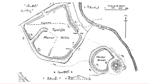
Cock Lodge at Topcliffe
“…a pretty manor place, standing on a hill, about half a mile from the town …”
John Leland, Itineraries
As shown in the map above, Cock Lodge, the moated fortified Manor House associated with the Percy family in the Wars of the Roses, was built elsewhere on the spur of land between the River Swale and Cod Beck. Much larger than the Maiden Bower Motte and Bailey, this site contained several buildings, not just the Manor House itself.
The site has five sides, which are still evident today from aerial photographs and Lidar images [see here]. The south eastern side faced the Motte and Bailey. The North West linked to the causeway that crossed the floodplains. Within the area that was developed for Manorial use is a 80 metre long ditch which runs from the south eastern edge of the area in a north easterly direction. This ditch marked a boundary between the Manor House itself and the associated buildings. In effect, it created a bailey area away from the Cock Lodge Manor House itself.
Extract from Humberston’s Survey 1570
“Topclyf is a stately manour, and ys scytuat vpon the water or river Swale, syxtene myles from York,
in the rodewey towardes Barwyke, wherin th’erle had his mansyon house in the Little Parke, for the most parte of his owne buyldying, all of tymbre and covered with tyle. And this last erle dyd moche delyght to lye there for the greate comodyte of huntyng and hawkyng in the feldes and small ryvers nere vnto the same manour, which are very well replenyshed with all kind of game and fowle, apt and mete for that pastyme.To the said maour belongyth two parkes, th’one called the Greate Parke, conteynyng in compas fyve myles, wherof one Christofer Stockdale is foster in fee, as apperith by a decree vnder the seale of the Courte of Augmentacions, and hath for his fee yerely lxs., xd.,
And suche other casuall proffittes as to the same apperteyneth. And the sayd parke ys well planted with wood and tymbre, and ys a very parkelyke ground and well replenyshed with deere. The Lytle Parke adioynyth to the south est parte of the towne, and ys very well planted with coppyes, woodes, and great tymber, and conteynth in compass iJ myles and a half, and ys well replenyshed wyth fallow dere; and to the same belongyth one keper, which hath for his fee yerly xs.,viijd. And suche other casual profittes and comodytees as to the same offyce apperteynyth.
The manour of Topclyf extendyth into the hamlettes of Skypton, Carleton, Catton, Greysthwayte, Thorpefeld, Assenby, Dalton, and Crakehall, the tenauntes wherof held their landes for the most parte by indenture for terme of certeyne yeres, and are very fynable after th’ expiracon of their leases……………
For all the tenantes of Spofforde anf Topcliffe, to my understandinge, be much dearer rented than thei be with us, and the groundes be not greatlie fruictfull, either by corne or grasse. Thei have great commons for the sommer tyme for stoore cattle upon the moores. In Spofforde and Topcliffe is muche great tymber, but muche spoiled with snaithinge, and the underwoodes cleane destroied both in the parke and outwoodes
Toplcliffe Parks
In the 14th century licenses were granted for two parks to be developed at Topcliffe. These were recorded as being Moskerry or Moskwith and Berbelond. In later records they are referred to as Great and Little Parks. The management of these parks was an hereditary office, for which records exist for the 15th century. Victoria County History for the North Riding notes the office holders during this period:
The office of forester of the Moskwith or Great Park was hereditary in the 15th century. Joscelin de Topcliffe left a daughter and heir Beatrice, who married Adam the Forester, and lived at the beginning of the 14th century. Their eldest son Alan died without issue and was succeeded by his brother Richard, who left daughters and co-heirs, Maud and Christina. Christina widow of William Berkesworth was succeeded in office by her daughter Margaret, who left daughters and co-heirs. Isabel the younger in 1454 quitclaimed to her sister Elizabeth and her husband Oliver Stockdale her right in the office, which carried with it a house, two gardens, an orchard, considerable land in the park, housebote and haybote.
‘Parishes: Topcliffe’, in A History of the County of York North Riding: Volume 2, ed. William Page( London, 1923), British History Online [The source page includes reference details for the above appointments and quitclaim].
The Percy-Neville Feud
When the Percy-Neville feud erupted into violence, Topcliffe was one of the notable Percy manors in the dispute. As it was close to several Neville strongholds, it was at the centre of the disputes. This was most notable when, in October 1453 when a Neville force headed by the Earl of Salisbury and his son, the Earl of Warwick, marched from Sheriff Hutton to Topcliffe. Both families had arrayed their forces and were effectively at full strength. Henry Percy, 2nd Earl of Northumberland, was at the head of his families force. It was the only ocassion in the Percy-Neville feud when the head of both families chose to be involved. They faced each other off outside Topcliffe. On this occasion there was no fighting, the Archbishop of York intervening and securing a truce.
Murder of Henry Percy, 4th Earl of Northumberland
On 28 April 1489 Henry Percy, 4th Earl of Northumberland, was slain by a riotous mob at Topcliffe. The crowd was rioting as a result of unpopular taxes that were being raised. The Earl was based at Topcliffe whilst overseeing the collection of these taxes and was targetted by the disgruntled crowd. It seems that his retainers and guards did little if anything to prevent the Earl from being attacked, though sources on the matter may not be entirely accurate. There have been some suggestions that the assailants were also disgruntled at the Earl for having betrayed Richard III, though this itself is a matter of debate: which is discussed in my book on Betrayal in the Wars of the Roses.
Maiden Bower and Cock Lodge at Topcliffe Links
Historic England – Official Listing of the site.
Heritage England – entry for Maiden Bower and Cock Lodge on the Heritage at Risk register.
Heritage Gateway – Description of the site with a selection of suggested sources.
Gatehouse Gazetteer – Description and suggested sources about the fortified manor at Topcliffe.
Topcliffe Village – pdf book of the History of Topcliffe.
Featured Image
Topcliffe Motte, Maiden Bower. Topcliffe Motte & Bailey was established by the Percies soon after the rising of the north in 1069. It would have been a wooden tower and palisade, and was refortified by Geoffrey Plantagenet, Bishop of Lincoln, in 1174. Behind the trees, now growing on the raised bailey, is an earthwork known as Manor Hills, which was the site of a newer house built by the Percies in the 14thC. Despite having 5m ditch a local mob breached these defences and murdered the 4th Earl of Northumberland in 1489. Additional: The field from which I took this picture is rapidly being eroded by the Swale & Cod Beck. Photo by Matthew Hatton,CC BY-SA 2.0 via Wikimedia.
